Camino de Santiago – León to Sarria

I  did my first section of the Camino Francés in September 2013 – from Sarria to Santiago. Like so many others who have dipped their toes into the Camino, the bug bit and the following year I walked from Burgos to León. This was followed in May 2015 – St Jean Pied de Port to Logroño – and in May 2016 I did the Logroño to Burgos leg. (I have written blogposts on them all – search “camino” if interested.) All that remained was the section from León to Sarria and I walked that over eight days this May. All done! Not as pure a Camino experience, no doubt, as doing it in one go over 33 or so days but I enjoyed my annual trips as well as the planning and the preparation and the always pleasant re-acquaintance with the wonderful country of Spain.

Day1 1

Statue of a weary pilgrim in León

Day1 2

Looking back at the Camino between León and Villar de Mazarife. My advice is not to stay at Villar de Mazarife – it’s a small town devoid of charm or interest. Go on to Villavante – or Hospital de Órbigo – instead.

My first day out of León was not auspicious – it was bitterly and unseasonably cold. I hoped this would not continue by the time I reached the Galician mountains in a few days as I did not have suitable warm clothing in my backpack. Thankfully, the weather improved dramatically the following day and, apart from an hour’s light rain outside Ponferrada, it remained calm, dry and warm for the rest of the time. Other than walking through a storm when traversing the Pyrennees on the St Jean to Logroño section I have been very lucky with the weather. People have spent a week and more walking in constant rain and it is an ever present possibility in Galicia given the province’s proximity to the Atlantic which, as we know in Ireland, can result in very variable weather.

Day2 1

Between Villar de Mazarife and Villavante. The long straight stretches are typical of the Meseta, the flat upland of Spain, and continue as far as Hospital del Orbigo when the landscape becomes more varied.

Day2 2

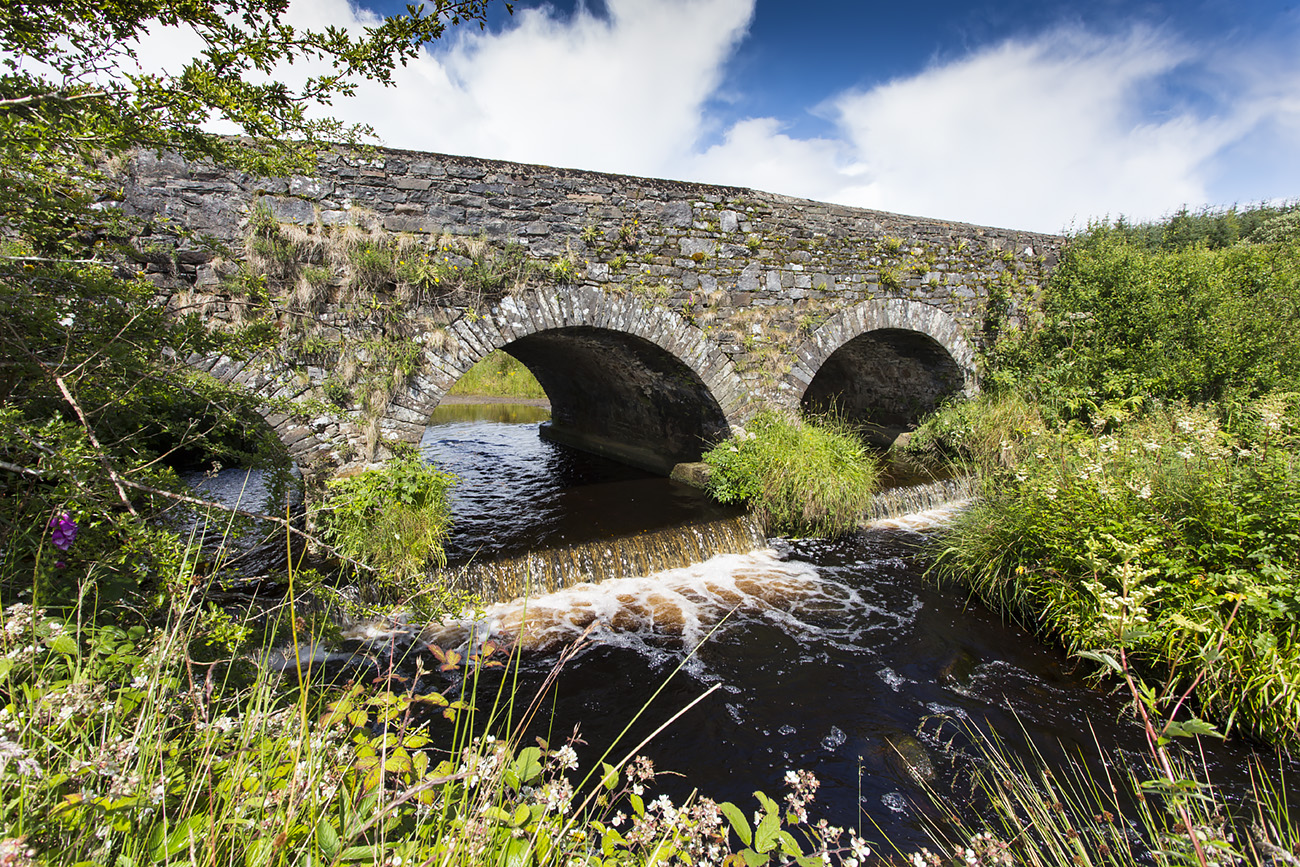
The bridge at Hospital De Órbigo.  The original was destroyed by the town’s inhabitants in the 19th century to slow the advance of Napoleon’s army into Spain. It was restored in more recent times.

Day2 3

Part of the gentle hill country beyond Hospital de Órbigo.

20170502_115428

Self and “friend” between Hospital de Órbigo and Astorga.

Day2 4

One is rarely out of sight of other walkers on the Camino.

Day2 5

The Cruceiro de Santo Toribio near Astorga.

I stayed in albergues – inexpensive dormitory bunk-bed accommodation – twice but in private rooms (hostals – similar to our B&Bs – and hotels) otherwise. I don’t like albergues for the simple reason that I am a very light sleeper and if there is a snorer in the room I find it difficult if not impossible to sleep. I bring ear-plugs but they are no match for a loud snorer and on each occasion this year I was unfortunate to be in a room with one. The first night I snatched some fitful sleep but on the second night – in O Cebreiro, after a very long, hard walk/climb – I got none at all as the snorer was as loud as a tractor. That municipal albergue cost me only €6 but it was a bad deal – I would gladly have paid ten times as much for a comfortable hotel room and a good night’s rest. The average cost of the private accommodation was €45 per night. Good value, in my view if you are a light sleeper. Otherwise, you can’t beat the value that albergues provide – private ones charge about €10 per night and municipal ones €5 or €6. Just be prepared to put up with noisy neighbours and be sure to pack good ear-plugs. An Australian woman told me she spent A$50 on a special industrial grade set and they were the only ones she found effective.

Day3 2

A colourful rest stop west of Astorga.

Day3 1

A stork in its nest atop a church steeple, a common sight.

The landscape varied from the flat Meseta upland as far as Astorga to the Galician highlands and valleys from thence to Sarria. Like any Camino section, parts of it were monotonous – especially where road walking was concerned (as in the 8 kilometre section through the industrial outskirts of Leon) – but it was mostly through beautiful verdant countryside accompanied by the sounds of birdsong (especially cuckoos – there was an abundance of cuckoos!).

Day4 1

The ancient village of Foncebadón. It thrived as a stop-off for pilgrims in the Middle Ages but by the 1990s there were only two people, a mother and son, living among the ruins.  Slowly, there are signs of a revival but most of the buildings are still shattered and derelict.

Day4 2

The Cruz de Ferro between Foncebadón and Manjarin. It is traditional to bring a stone from one’s place of origin and place it on the mound.

Day4 3

Items  in memory of loved ones at the Cruz de Ferro.

The highest point of the journey – and the highest point of the entire Camino Francés – was between Rabanal and Molinaseca at an altitude of 1,505 metres (the Col de Lepoeder on the Pyrennees is 1,300 metres). The climb up to O Cebreiro (1,300 metres) was the toughest day of the lot but it more than made up for the effort with the magnificent views of the surrounding countryside.

Day4 7

The highest part of the entire Camino Francés.

Day4 9

The descent to Molinaseca requires great care. I’m glad I didn’t have to negotiate it in wet eather.

Molinaseca

The view from my bedroom window in Molinaseca. The bridge over the River Meruelo dates from Roman times.

Day5 1 Villafranco del Bierzo

Approaching Villafranco del Bierzo. Some stretches of the Camino are on public roads but they are generally not very busy as the motorways have taken most of the traffic.

I had been looking forward to O Cebreiro for more than the views. Here is buried a man without whom we probably wouldn’t have the Camino as we know it today and I was anxious to pay my respects at his grave in the little village church. Elías Valiña Sampedro, originally from Sarria, was the Parish Priest of O Cebreiro. He had an abiding interest in the history of the Camino and in 1965 he did his doctoral thesis on the history of the pilgrimage in the University of Salamanca. When the authorities in post-Franco Spain decided to promote the route for historical/cultural reasons Elías Valiña was at the forefront of the campaign. It was he who came up with the idea of the iconic yellow directional arrows which every walker depends upon. In the late 70s he loaded up his battered old Citroen with cans of yellow paint and set about painting arrows to mark the way. He was once stopped near the French border by two suspicious Guardia Civil and asked what he was doing; he answered that he was preparing for a French invasion! Alas, he died in 1989 at the age of 60, too soon to see the enormous increase in pilgrimage numbers in subsequent years. In 1989, 5,760 people received their Compostela (a certificate of completion) in Santiago; in 2016, it was 277, 915. He was a great man and all of us who have walked any part of the Camino owe him a huge debt of gratitude.

Day6 2

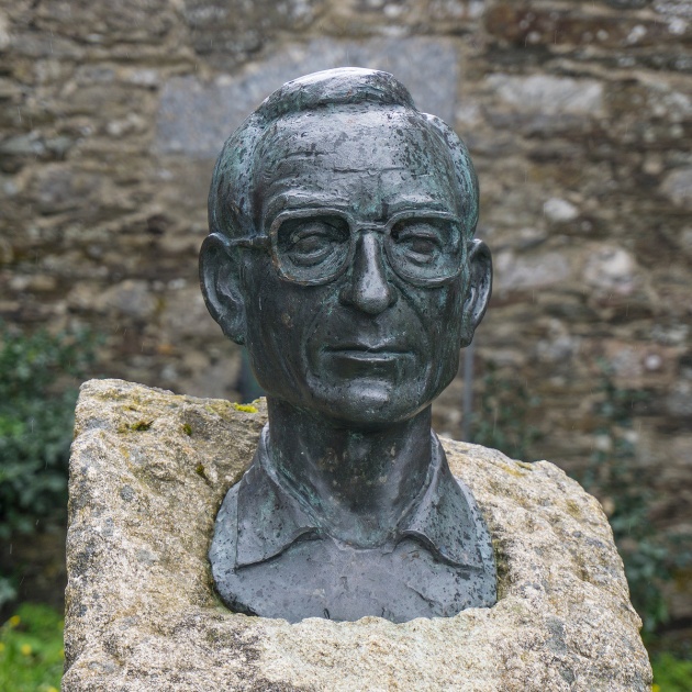
The bust of Elías Valiña at the church of O Cebreiro.

Day6 5

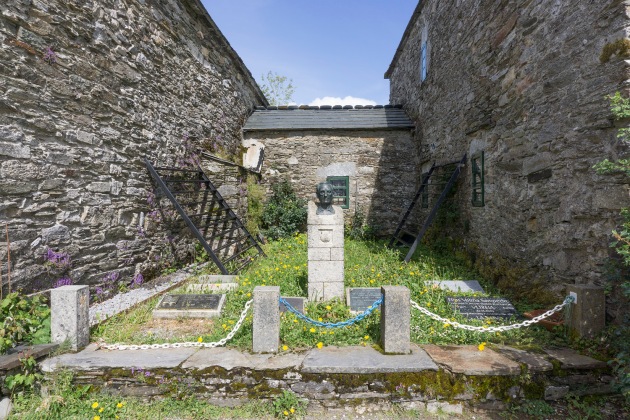
The bust surrunded by various commemorative plaques.

Day6 3

His grave in the church. It reads (my rough translation of the Latin):  “Dr Elías Valiña Sampedro, Parish Priest of this place and famous restorer of the Way of St James and friend and brother to all pilgrims”.

Day6 4

One of the many plaques commemorating him. “Thanks and Peace to Don Elías Valiña who preceded us all in the love of the Camino”.

Day4 8

The yellow arrow, symbol and indispensable navigational aid of the Camino, brainchild of Elías Valiña.

There is a bust of him on a plinth outside the church but it seems few people pay it any attention. I sat on the wall opposite it for 30 minutes and in that time not a single person stopped to examine it. Anyone who did give it a passing glance probably thought it was a memorial to a local politician or something. Nor is this lack of awareness of the man unusual in my experience – I have spoken to Camino veterans who have never heard of him. Which is a pity given the importance of his research and scholarship to the revival of the Camino in modern times and the fact that his genius idea, the ubiquitous yellow arrow, is not only a symbol of the pilgrimage but an essential aid for everyone on the trek. Anyhow, visiting his final resting place was something I had long looked forward to and was the highlight of my 2017 Camino.

Day6 8

The view from O Cebreiro looking back towards the province of Castilla Y León.

As I mentioned, I got no sleep that night in O Cebreiro and I was out the door and on my way the next morning at 5:45. It was still dark – sunrise wasn’t until 7:16 – and I had to use my head-torch to find my way for the fist 30 minutes or so. I had 22 kilometres to go to my next destination, Triacastela, and I wasn’t sure if tiredness would prevent me from walking all the way. My plan B was to call a taxi if necessary. In the event, I got there without any problems and the fact that the day was one of glorious sunshine and the countryside was so picturesque buoyed my spirits and helped my forward momentum. I need hardly add that I did not stay in an albergue that night in Triacastela nor on any night thereafter. And never again, I hope!

Title

A statue of a pilgrim at the Alto do San Roque (1,270 metres) between O Cebreiro and Triacastela.

20170507_100921

En route to Triacastela.

20170507_094645

Verdant Galician countryside.

The walk from Triacastela to Sarria via Samos was mostly though beautiful woodland along the banks of the River Oribio. This was the Camino in idyllic pastoral mode. Approaching Samos I heard the sound of a church bell and then, through a gap in the trees, there was the famous Benedictine monastery below me. I stopped off there for a guided tour and afterwards in a nearby café, had lunch with Brendan from Cork and Jim from California whom I kept meeting along the way.

Day8 1

The Benedictine Monastery at Samos.

Day8 2

The Monastery.

Day8 3

Between Samos and Sarria.

Day8 4

Journey’s end – Sarria.

And then it was on to Sarria, my final destination, and the town from which I did my first Camino. I stayed in the same place as I did back then, conveniently located on the Camino just on the entrance to the town.

I had closed the loop.

Which of the five sections – St Jean Pied de Port to Logroño; Logroño to Burgos; Burgos to León; León to Sarria; Sarria to Santiago – would I do again?

Each has its attractions but the one I’d go back to, I think, is Burgos to León. That is the section that a lot of people avoid because it is across the Meseta and is regarded as being too flat and monotonous. I loved it. I loved its wide open expanses and its big skies. I loved setting forth very early a couple of mornings and walking by the light of the moon. Standing alone in the vastness of the Meseta, in a place where millions of pilgrims had trod before me, and staring up at the heavens was a numinous experience that I shall long remember.

DSC05351

The road goes ever on … across the Meseta.

Why do it at all?

Why indeed. A thousand years ago and for hundreds of years afterwards people did it for religious reasons, to gain an Indulgence in order to minimise their time in Purgatory. They set forth from all over Europe and spent months – sometimes years – walking all the way to Santiago and back again. We may smile at their simple credulity but the pilgrimage was, in my view, one of the great civilising enterprises of medieval Europe. People from across the continent would have met each other en route and exchanged knowledge with one another. When they returned to their towns and villages they would have seeded their communities with new techniques and insights.

And consider how brave it was back then for people to undertake such a hazardous journey- people who, for the most part, would never have previously traveled more than 10 miles or so of their homesteads. They set out into unknown territory and all its attendant hazards – bandits, wild animals, dangerous terrain. All in the service of a compelling religious imperative, one that even the most devout modern believer would find it difficult to comprehend.

I don’t think too many people nowadays do it for overtly traditional religious reasons (and certainly not me) but it is impossible for even the most secular of us not to contemplate the motivations of those who went before us and to imagine what difficulties – and joys! – they experienced.  There is a awareness of being part of an ancient tradition and one that may well  last for another thousand years.

Why do it? It’s a retreat, of sorts. A retreat in the Christian tradition is time spent away from normal, everyday  life for the purpose of reconnecting with God. Define God, if you like, as one’s Higher Self, or The Cosmos, or whichever Post Christian or New Age notion that you find fitting. The time away from normal life is a powerful incentive. You leave your family and friends and disappear into the fastness of Northern Spain for a time and forget (as much as one can in this age of connectivity) about the world of everyday routines and concerns. A County Longford woman I met had her phone with her but carried it just in case her family needed to contact her urgently. She did not connect to the internet and other than hearing other walkers talk about news items she was blissfully and deliberately unaware of what was happening in “the real world”.

It is a pilgrimage, of course,  and in all religious traditions a pilgrimage consists of a journey to a holy place for the purpose of gaining spiritual knowledge and renewal. The physical journey is a metaphor for the human one and like every human life is beset with disappointments, sacrifices, torments (snorers! blisters!) and the like as well as bountiful joys.

The medieval pilgrims believed that the bones of St James the Apostle lay in the sarcophagus in Santiago; there is no modern historian who gives that legend any credence – it was devastatingly demolished by the French historian (and Roman Catholic cleric) Louis Duschesne in his 1900 paper “Saint Jacques en Galice” (St James in Galicia).  There is in fact a better case to be made for the bones to be those of Priscillian, a 4th century bishop of Ávila who was put to death for heresy.

Louis Duschesne

Louis Duschesne – he brought modern historical methods to bear on the Saint James in Galicia legend.  He was a Monsignor of the Catholic Church.

Tomb

The tomb in the Cathedral of Santiago purportedly containing the bones of Saint James.  It is highly improbable that it does.

One can simply regard it as a good physical and mental work-out in pleasant countryside and with the opportunity to meet agreeable and interesting people. It’s no walk in the park though – you need to be fit and willing to undertake physically and mentally challenging walks day after day. It will be the hardest walking that most people will ever do.  Day three is often the day of reckoning for the unprepared – exhaustion, blisters, tendonitis, plantar fasciitis and other ailments can manifest themselves by then and can result in the end of the Camino for the unfortunate sufferers.  Forget about any romantic notions of having epiphanies around every corner or life changing encounters in albergues: think more of grindingly long trudges in weather that can vary from days of torrential rain to oven-like temperatures in high summer followed by spartan accommodation and basic food. There were times when I looked up at the jets heading south to the Costas and envied those aboard who would be sipping Margaritas by the pool in a couple of hours. And yet despite the hardships, the Camino casts a seductive spell. Walking it has been one of the best things I have done in my life.

Some Practical Advice

Blisters – How I Avoid Them 

There are numerous suggestions for avoiding blisters. This is mine. Make sure you prepare for the Camino several months in advance by regular walking. Get your feet used to pounding the pavement.

Wear a pair of 1000 Mile (trademark) walking socks – they have a dual layer construction which, they claim, guarantees against blisters.

Have a right sock and a left sock and – advice given to me by a Camino veteran – wear the same socks on the trail for three to four days at a time before washing them.

Gehwol

Use Gehwol foot balm before and after each day’s walk. Some people use Vaseline – Gehwol (available only from Amazon) is far better.

Travel to León

I flew from Dublin to Madrid with Aer Lingus and got the 14:40 Ave train (300 kph!) to León. When you arrive in Madrid Terminal 2 get the free airport bus to Terminal 4. From there get the train (not the Metro) to Chamartín train station. It costs €2.60 at the automatic ticket machine.  It’s best to book the Madrid to León train online at Renfe.es. The two-hour trip cost me just €16.55.

Sarria to Santiago de Compostela. 

(I flew back to Dublin from Santiago.)

There is a regular bus service from Sarria to Lugo.  It takes about 30 minutes. It’s not possible to book it online. Check out Monbus.es for the schedule. The Lugo to Santiago coach leaves at 10:45 and takes the motorway via A Coruña. It arrives in Santiago around 1:15 pm.  Book it online at Alsa.es. It cost me €9.00.

Camino Francés – Logroño to Burgos

I was waiting outside the Bilbao Airport terminal for the bus into the city after my flight from Dublin when I was approached by a young Irish woman who asked me if I had been at that airport in September 2014.

I had indeed, en route to and from the Camino Francés section I had done that year – from Burgos to Léon. Helena – that was her name – had recognised me from that time. She and her friend Gabrielle had also done a section then and like me were now returning in May 2016 to walk from Logroño to Burgos

Many Irish people like Helena, Gabrielle, and myself opt to do the Camino in sections – a week or two at a time – rather than the full route which typically takes about 30 days. The airfare is cheap and not everyone has either the time or the desire to do the whole thing in one go.

People outside of Europe  generally commit to the entire Camino. In most cases it’s a once-in-a-lifetime opportunity and the airfares from the States, Australia, South America or wherever are too expensive to warrant doing it in stages. Plus there’s the more authentic experience that walking it without interruption for a full month or more provides.

0847

Bilbao’s Guggenheim Museum 

I stayed overnight in Bilbao and had an early night as the following day I was catching the 6:30 a.m. train to Logroño, the endpoint of my stage last year, and then a long 30km walk to Nájera.

The journey to Logroño from Bilbao’s Abando station took 2.5 hours. A walk of 30 minutes from the station got me to the Camino which is marked by directional signs all along its length. It was now 9:30 a.m. which was a little late to be setting out from the city – most peregrinos  (pilgrims)  would have left before 8 a.m. Still, there were people – singles, couples, groups – ahead of me and behind me. One is rarely if ever alone on the Camino – if you don’t see anyone up ahead or to the rear you may possibly have taken a wrong turn.

0848

I joined the Camino at this point

There was now a long 30km walk to Nájera. My 2016 Camino had begun.

Which prompts the question – why do it?

The Camino is no walk in the park. It requires stamina, strength and determination to withstand daily walks of between 20 and 30 kilometres. You have to be physically and mentally prepared. It’s often bloody hard work which will leave you exhausted at the end of the day. Physical issues – especially with your feet – that you may not be aware of if you haven’t been doing long training walks will very quickly manifest themselves. The food is just adequate and the accommodation – especially if you stay in the albergues (hostels with mixed-sex, bunk-bed dormitories) – can be spartan, not to mention uncomfortable and noisy. Plus there’s the Northern Spanish weather to contend with – days of torrential rain are not uncommon in the Spring and Autumn, the best times to do it as the heat of Summer can be too intense.

Some people, I think, have unreal expectations of the Camino. There was a thread on the Camino Francés internet forum originated by an American woman who asked: “where is the ecstasy?” She had heard so much hype about it being a blissful life-changing experience that she was disappointed by the reality. It was “just a series of very long walks”.

I met an Australian woman near Belorado who likewise was regretting her journey. She had been attracted to the idea of the Camino but had not appreciated the difficulties involved. Her feet hurt, she had blisters, she found her body didn’t really loosen up until the afternoons but, because of the need to get to an albergue early in order to have a bed for the night, she had to continue setting out early in the day. She “had no idea what it was I was thinking” when she committed to doing it and she regretted her decision.

So why do I do it?

Because I can, is one answer. I am of an age where I am very conscious that the time may soon come when I may no longer be able to do it. Carpe diem and all that.

Then there’s the experience of walking through the often very beautiful Spanish countryside not knowing what’s around the next corner or over the next hill.

And there’s the wide variety of people that one meets, people who are often interesting and/or funny. I think one of the biggest attractions of the Camino historically has been the meeting of minds that it lends itself to. When medieval pilgrims set out for Santiago – in most cases probably the only long-distance journey they would take in their lives – and met others from different countries or provinces the resultant exchanges of views and knowledge must have had a positive seeding effect when they returned to their respective communities. That was a time when travel really did broaden the mind.

The Camino is well serviced by accommodation – everything from the basic albergues to (for an occasional treat perhaps) Parador hotels in the major cities. Nor is there any rip-off. The prices are very reasonable and there is free WiFi in practically every place you stay.

The food is OK if not exactly haute cuisine. A typical pilgrim’s meal available in alburgues and restaurants along the way consists of a starter (e.g. a mixed salad), a main course (e.g. chicken and chips – *very* common) and a dessert (e.g. ice cream – often a choc ice in its wrapper).  To drink you’ll usually have either water or wine and the wine is served by the bottle. All that for about €10. Very good value.

Finally, there is the getting-away-from-it-all feeling, leaving the real world of bills, politics, responsibilities and all that stuff behind, opting out of the normal routine for a while, focusing instead on the day’s stage, how long it’s going it take, where to stop for refreshments, getting into a walking rhythm and generally feeling better every day as the physical exertion releases all those happy endorphins. And at the end there is the sense of achievement of once more having finished it successfully.

That’s why I do it.

0854

This interesting looking man was selling fruit and cakes at a stall nor far from Logrono. He had no set prices – people were free to donate what they wished. A wise strategy , I think – he probably got a lot more than he would have had he charged normal prices.


0855

Vineyards abound in the Rioja region 

Navarette

Approaching Navarette

Navarette Old Pilgrims Hosp

The remains of an old pilgrim hospital at Navarette

Najera

Approaching Nájera – the first day’s destination   

Najera River

The River Nájerilla as I passed over it the next day leaving Nájera

Najera 3

Looking back in the direction of Nájera

Near Santo Domingo

Between Ciruenda and Santo Domingo de la Calzada. The vineyards of Rioja are mostly behind us and we are now in cereal growing country – from wine to bread. 

Near Ciruena

Looking back from near Ciruena

A word of caution in respect of accommodation: the Camino is in a sense becoming a victim of its own success. I have heard and read many stories this year of alburgues becoming full up relatively early in the day. People are setting out often well before dawn in order to be sure of getting a bed for the night at their destination. This can be very stressful and it can rob people of the enjoyment they should be experiencing.

I have always booked my accommodation a few months before travelling and this year I was very glad I did so. I had no worries about where I would stay any night as I had reservations in every place I stayed. (I use Booking.com – an excellent accommodation booking service.)

One way over the problem is not to do Brierleys. John Brierley has written the definitive guide to the Camino Francés and he recommends daily stages – Brierleys – that people (including me) tend to blindly follow. So, for example, stage 9 of the Brierley guide is from Nájera to Santo Domingo de la Calzada, 21 kms. The result is an influx of pilgrims into Santo Domingo and if the numbers are excessive there may not be enough beds to go around. What people should do instead is either stop 6kms before Santo Domingo at Ciruena  or continue walking another  6kms as far as Granon. Don’t slavishly follow Brierley; do your own stages and you should have no problems if you haven’t booked ahead.

Alburgue

Alburgue beds. This is the albergue I stayed in at Agés. It was very cold and I did not have a sleeping bag, just a light sleeping bag liner. Brrrrrr!

I also tend to use hostals rather than alburgues. Hostals (not to be confused with hostels) give you your own room and bathroom and so are very conducive to a good night’s sleep. Alburgues on the other hand are mixed dormitory bunk-bed establishments and you can be very unlucky if you are (like me) a very light sleeper and one or more of the other residents are snorers. Or if someone gets up in the middle of the night to go to the toilet and make a racket in the process. Or if they decide to set out at an unearthly hour and wake everyone else up while they noisily make preparations. On the plus side, albergues are cheap and the communal evening meal is a great way of getting to know people.

There are travel companies that will pre-book all the accommodation for you and will also transfer your bag from one location to the next. Go for it if such convenience appeals to you but be prepared to pay through the nose. It is much cheaper to do it yourself. Nor is it a problem carrying your stuff on your back. I actually think it’s beneficial to walk with a backpack as it keeps your back straight. Several people who suffer back problems have remarked on how it has helped them. The trick is in choosing a good backpack and carrying only the minimum. Aim for a combined backpack/contents weight of about 7 kgs.

Camino3

My backpack and its contents; total weight 7kgs.

Santo Domingo

Approaching Santo Domingo de la Calzada

SantoDomingo De Calzada

A view from the bell-tower of the church of Santo Domingo de la Calzada.

In Santo Domingo de la Calzada I stayed in the Hospideria Cisterciense, a hostal run by Cistercian nuns. And very nice it was too. A notice at reception stated that a daily Mass for pilgrims would be held at 7 pm and I decided to go. I had been expecting a large group of pilgrims to be present at the small church but there was only myself and a French woman – the other dozen or so attendees were elderly locals, mostly women. The priest was very elderly and frail and the poor man was on crutches and had to be assisted to the altar by a nun. He sat down behind the altar to say Mass. Communion was distributed by the nun. At the end the priest gave the usual blessing and, as this was a Mass for peregrinos, bade all walkers a Buen Camino! –  the traditional Camino greeting and farewell that everyone uses.

Santo Domingo Rio Oja

The River Oja at Santo Domingo  

Santo Dom to Belorado N120

Some sections of the Camino are adjacent to busy main roads as at here outside Santo Domingo. This third day from Santo Domingo to Belorado was my least favourite part because of the nearness and the noise of the highway.

Near St Juan De Ortega

Day 4 between Belorado and Agés – a lot of today’s section was through forest.

Self

Myself at a stop in the forest a few miles before St Juan de Ortega. A girl had made these artworks and was selling fruit and juices. It was very cold during this stage but then again the elevation was around 1,000 metres.

San Juan Forest

The path through the forest before St Juan. 

Ages

Agés

Ages 2

The Camino at Agés 

My last day – day 5 – was from Agés into Burgos. There was torrential rain and it didn’t let up until I was well into the city. I finished about 1 p.m., stayed overnight in Burgos, got the 10:30 a.m. train to Bilbao the next day and flew back to Dublin the following day, Saturday.

Everything had gone according to plan and, once again, it was a most enjoyable Camino.

Next year my plan is to do the stage from Léon to Sarria and that will complete my Camino Francés.

After that, who knows? I may repeat a section, or I may do one of the other Caminos such as the Portugués or the Del Norte. Or perhaps walk from Santiago to Finisterre.

So many options, so little time!


Details of my previous Camino trips can be found on this blog at:

Camino de Santiago: Sarria to Santiago

Camino de Santiago – Burgos to León

Camino de Santiago – St Jean Pied de Port to Logroño


Source of the River Blackwater

The River Blackwater, Ireland’s second longest river after the Shannon, rises in Knockanefune Mountain in County Kerry, in the area known as Sliabh Luachra, near the Cork/Kerry border. It flows for 104 miles in an easterly direction through Counties Kerry, Cork and Waterford where it turns abruptly south at Cappoquin and flows into the sea at Youghal, County Cork.

BlackwaterSourceMap2

The “B” shows the location of the start of the walk to the source of the river.

The Latitude and Longitude of the walk start are: 52.20605879, -9.28824804. If you use the useful Loc8 system on your SatNav the code is: QZ3-89-FF7.

This is a closer look at the location:

BlackwaterSourceMap

Again, “B” is the start of the walk. You proceed in a northerly direction, following the blue waymarked signs, until you arrive at the source (circled). It takes about 45 minutes. It is possible to drive the route but be careful of potholes. Really though, you should walk it. At the source you have a choice of going back the way you came (which is what I did) or continuing the looped walk which takes about 2 hours 30 minutes to complete.  There are two looped walks here – one is waymarked in green, the other in blue; blue is the one you need to follow.

BlackwaterSourceMap3


BlackwaterSource

The source.

BlackwaterSource5

It’s hard to believe that such a small flow of water will become a mighty river.

BlackwaterSource2

The start of the Blackwater Valley. The source is at the top of the path and even though the river is not visible here it can be heard flowing through the reeds on the right.

BlackwaterSource4

The first bridge – near Doctor’s Hill, a few kilometres downstream.

BlackwaterSource3

And so the River Blackwater continues on its journey until it reaches the open sea at Youghal.

Camino de Santiago – St Jean Pied de Port to Logroño

This is an account of my Camino trip from 1st May to 7th May, 2015.  I have previously walked from Sarria to Santiago and from Burgos to Leon and I have written about those trips also on this blog (search under “Camino” if you’re interested). Click on the photos for full size.


I closed the door gently behind me and stepped into the chill night air. 4:55 am. Two hours before sunrise. The Camino path was just around the corner and the way was lit by the streetlights of Los Arcos. In a hundred yards or so I was into the dark countryside. As bright as the moon was, I needed my head-torch to see the way – it would be very easy to miss one of the Camino markers. The night was still. As soon as I was well away from the lights of the town I stopped and turned off the torch so as to savour the sounds and sights of this part of rural Navarra. A dog was barking somewhere in the distance. A few birds were singing in the fields – which surprised me given this early hour. A car passed on a nearby road. The contours of the land were easily discernible thanks to the nearly full moon. Flashing lights on the horizon marked a line of wind turbines. The lights of Sansol, the next town 7kms away, were due west of where I was. Of humans, fellow Peregrinos, there was no trace. I was alone.

20150507_063716

Dawn on the Camino

Looking at the night sky and seeing the land by the light of the moon is something I like to experience at least once during my Camino treks. I like to get out early when few others or none are about and then walk into the light. The symbolism of doing so on this ancient pilgrimage route is obvious but I just enjoy the sense of wonder and awe that it produces. But enough. I had to press on. This was my last day of walking and I had 30 kilometres to go to get to my final destination – the city of Logroño.

Six days previously I had set out from St Jean Pied de Port on the French side of the Pyrenees. The morning had been overcast but visibility was good as I made my way up the paved road towards the hostel at Orisson where I would stop for breakfast. Even though the highest point of the Route Napoleon over the mountains – the Col de Lepoeder – is 1,450m there is a gentle enough ascent: the steepest part, such as it is, is between the Huntto and Orisson hostels. It really is no big deal and it is on a paved road for most of the way. Forget any images you may have of scrambling up a steep mountain.

DSC06470

DSC06473

St Jean Pied de Port on the French side of the Pyrenees – the traditional starting point for the Camino Francés

However, about 30 minutes beyond Orisson the weather turned bad: a gale force headwind began to blow and rain became torrential. As we ascended it became colder – there were traces of snow in places – and the walking conditions were miserable. All one could do was struggle on at an angle of 45 degrees into the wind and rain and grit one’s teeth with determination to get the hell over the mountain as quickly as possible and down the other side to Roncesvalles. Again, to emphasise the point, these were conditions that would have seen a mountain climb at home abandoned for fear of falling or getting lost but there was no such danger here (the way was well marked at all times) – it was just very uncomfortable.

DSC06480

On the ascent out of St Jean Pied de Port

DSC06486

Near Orisson

DSC06490

Looking back just before the bad weather struck. 

DSC06499

Fog, rain and wind

DSC06504

DSC06501

A clump of snow on the summit

I was glad I had brought my walking poles this time. They provided much needed support on the descent down the muddy woodland path on the Spanish side. I had been hoping for a hot meal at one of the restaurants in the town but everywhere was full up so I continued on to Espinal, 6kms away, where I had booked a bed for the night. I was glad I had. The large albergue at Roncesvalles, I heard later, was packed out and people were even put up in converted shipping containers such was the demand for spaces. The hostel at Espinal, by contrast, had plenty of beds to spare. It may have lacked the camaraderie and sense of achievement that would have been in evidence in Roncesvalles but it made up for it in comfort and quiet. It had taken me 8 hours to walk the 32kms from St Jean Pied de Port which was pretty good going in the circumstances.

Happily, the weather cleared and the rest of the trip was calm and rain free. The next two sections – as far as Pamplona – were mostly through woodland with the path still sticky in places after the rain. The woods were beautiful with the trees wearing their fresh green leaves and the birds in full song. Near Zubiri a cyclist who had just passed me fell on an exposed bare rock section of the path as it descended towards the town and broke his leg. He had to be lifted out by helicopter.

DSC06507

Brighter, drier conditions on the second day. Note the snow on the mountain in the middle distance

DSC06508

DSC06564

A cyclist on the ascent of the Alto de Perdón with Pamplona in the background 

20150504_105906

One of the iconic structures of the Camino, the Monumento Peregrino on the Alto del Pedrón – a series of natural sized iron figures representing pilgrims of a former age who would have done it on horseback or riding donkeys as well as on foot.

20150504_110001

A  peregrino with donkey (the donkey is on the left)

After Pamplona the countryside opened out and from there on each day brought us through some of the most scenic parts of the Camino. Walking conditions were ideal – a cool breeze and mostly overcast with occasional sunshine. And, of course, as ever on the Camino – good company: as well as the scenery, the opportunity to meet interesting and amusing people from all over the world is one of the great attractions of the walk. I was astonished to find, in a hotel in Puente La Reina, an old schoolmate of mine whom I hadn’t seen for over 40 years. He was walking with his wife as far as Estella, had heard about me from other Irish people whom I had met on previous days, and approached several men in the hotel asking them if they were me – I have changed over the years after all  – until he found me. It is indeed a small world.

20150505_122422

One of the most remarkable women I met – Texan woman Leigh Ann Peters who lives in Colorado has taken a year out to backpack around the world and has been travelling since last November. After doing the Camino she intends to travel around Europe and then on to South America before returning home for her son’s wedding in October  

20150505_171658

San José, California man Greg with a fellow American girl cooling their feet in the river at Estella 

DSC06578

Walking towards Maneru

DSC06585

Remnants of the old Roman road, 2000 years old, outside Puente La Reina 

DSC06584

An elaborate map of the world in a field 

DSC06572

A handy reminder in Uterga as to how far Puente La Reina is

DSC06615

Free wine at Irache – just put a container under the tap and pour

DSC06625

DSC06662


DSC06654


DSC06646


DSC06639

DSC06691

Journey’s end – Logroño

But now, here I was, alone in the pre-dawn heading towards Logroño. The towns of Sansol and Torres del Rio were asleep as I passed through and in the absence of any open restaurants I breakfasted, on the hoof, on my energy bars and orange juice. By the time I got to Viana people were up and about and I had coffee and a tortilla in a little café in that picturesque place. Then it was time for the final push towards Logroño and just before the city I passed from Navarra into La Rioja with vineyards producing that excellent wine in abundance all around. As I sat in one of the city’s plazas I contemplated the finish of another Camino section, the people I had met, the beautiful country I had passed through and I looked forward to doing another one next year.

Carrauntoohill, December 2014

Carrauntoohill-Dec14-2

Carrauntoohill is the large peak on the right

I’ve been hillwalking in the MacGillycuddy Reeks since the 1980s and I’ve probably been up Carrauntoohill, the highest peak in the range at 3,406 feet – and the highest in Ireland – at least once a year over that time.

It was in the news recently when some people carried an angle-grinder to the summit and cut down the steel cross that had stood there since 1976. This was in protest, apparently, at the number of schools run by the Catholic Church in Ireland. The culprits have not been identified nor are they likely to be.

The incident resulted in some debate in the media as to what should be done – should the cross be re-erected or, as Atheist Ireland recommended, should there be a “more inclusive” symbol put in its place – if, indeed, there should be any object put there at all. The need for planning permission was mentioned, something that was not of concern back in 1976.

In the event, one week after the felling, the cross was re-erected by a group of local people and there it stands none the worse for its sudden impact with the stony ground. The culprits unwittingly helped in its swift restoration due to the clean cut at the base and because they did not cut it into pieces and hurl them down the steep northern side of the mountain. I suspect that once they felled it they got out of the area as quickly as they could.

I’m glad it’s back upright. The first sight of the cross as one makes one’s way through the last few hundred feet to the summit is always a relief – finally! I’ve made it! In poor visibility it serves as a useful landmark. I’ve never regarded it as a symbol of Catholic triumphalism – it’s just a simple steel cross that has been there for a long time and the summit would not be the same without it. Leave it be.

The incident prompted me to make another trip to Carrauntoohill last Saturday. The recent cold weather would have the Reeks looking their best with their winter raiment of snow. The forecast was for good sunny spells and the only consideration at this time of the year was the hours of daylight – it would be getting dark shortly after 4pm and the round trip to the summit would take about 6 – 7 hours so an early start was necessary. I left home around 5:45am for the 1.5 hour drive to the starting off point at Cronins’ Farm and I began my trek up the Hag’s Glen at 7:30am. The sky was beginning to brighten but a head torch was necessary for the first 20 minutes or so.

Carrauntoohill-Dec-14-Sunrise

Sunrise behind the Eastern Reeks

Carrauntoohill-Dec14

Sheep crossing my path up the Hag’s Glen  

Carrauntoohill-Dec14-6

The first rays of sunlight hitting the flank of Carrauntoohill 

My route was up the glen and thence the ascent of the Devil’s Ladder – a 500 feet steep gully – on to the saddle (a narrow, level stretch of ground between Carraountoohill and the Eastern Reeks) and thence the remaining relatively easy 1000 feet to the summit. This is the most popular route although there are more interesting options such as via The Bone, The Heavenly Gates or O’Shea’s Gully.

Devils-Ladder

Ascending the Devil’s Ladder

The snowline began about half way up the Ladder and it was thick on the ground on top. The usual path was not visible due to the snow and so I just followed the footsteps of a climber ahead of me. By the time I got to the summit visibility had significantly worsened. It was obvious that there wasn’t going to be any sunlit vistas of the Reeks anytime soon and it was too cold to linger there for  long. After a bite to eat I set off back down the slope. It was snowing now and the marks of my footsteps on the way up were becoming indistinct. I was soon down below the cloud however and the saddle at the top of the Devil’s Ladder wasn’t too far away.

Carrauntoohill-Dec14-3

Looking towards the summit of Carrauntoohill from the top of the Devil’s Ladder

Carrauntoohill-Dec14-5

The first glimpse of the summit cross in the deteriorating visibility

Carraountoohill

I usually try to avoid going down the Devil’s Ladder as it can be awkward to negotiate and there is a lot of loose rocks to contend with. However, my preferred option of descending via the Zig Zag path would have meant climbing Cnoc an Toinne the top of which was above the cloud line and I wasn’t prepared to deal with poor visibility in the snow. I made my way down the Ladder therefore and my walking poles gave me badly needed support.

It was disappointing that despite the good weather forecast the night before there wasn’t a clear sky on top. The views are spectacular when there is and especially so when there is snow on the mountains. Still, seven hours traversing this wonderful part of Ireland is always a pleasure regardless of the weather.

Camino de Santiago – Burgos to León

In September 2013 I walked my first part of the Camino de Francés from Sarria to Santiago and I wrote about it here: https://carrigmanblog.wordpress.com/2013/09/28/camino-de-santiago-sarria-to-santiago.  Like many others who have walked a section of the Camino, I returned to do another part of it and in September of this year I walked from Burgos to León, a 180 km trek across the Meseta.

This was a different landscape entirely to the Sarria to Santiago section which was through countryside very much reminiscent of parts of Ireland. The Meseta is open and mainly flat with wheat fields stretching as far as the eye can see. Some people hate it for its relative monotony and lack of variety. I loved it. I found the landscape to be quite beautiful and some of the towns and villages were far more picturesque than any I came across in Galicia.

I had timed my trip to coincide with a full moon – something I would recommend to anyone doing a week or two at a time – and it was a wonderful, numinous experience walking a few mornings in the still countryside bathed in bright moonlight a couple of hours before dawn. Even at those early hours there were other peregrinos (pilgrims) on the path. I even heard of people who walked only at night and slept by day- which is a bit extreme.  However. doing at least one very early start – 5am or thereabouts –  when there are clear skies is a must-do.

I have added a section below the photographs containing some practical advice for anyone thinking of doing the Camino either in whole or in part and information on what worked for me.

Here are some photographs that give an idea of what the route is like – click on them to see them in larger size:

DSC05307

The first day out from Burgos, the outskirts of the city have been left behind, and we are on the Camino proper. 

DSC05328

The wheatfields are full of stubble now as the wheat has been harvested.

DSC05340

DSC05351

One of the iconic views of this section  – downhill towards the village of Hornmillos del Camino.  Roman legions would have passed this way.  

DSC05349

The well dressed peregrino! Note the wide-brimmed Tilley hat to guard against the sun and the Buff neckband – a versatile piece of cloth that can be used as a headband, neckband, etc. Ideal for dunking in a water fountain and putting on one’s head to cool down. Brierley’s book of maps sticking out of the left Craghopper trouser pocket.  The walking poles are not mine – they belonged to the photographer. I didn’t use walking poles but most walkers did.  They’re probably more useful in more hilly terrain than the Meseta.

DSC05354

A panorama of typical countryside. 

DSC05374

Just after dawn.

DSC05708

The ubiquitous yellow directional arrows mean that it is practically impossible to lose your way. The Camino is exceptionally well signposted.  

DSC05400

Another of the yellow arrows as well as the scallop-shell sign pointing the way. 

DSC05640

Occasionally the Camino intersects with a public road. The STOP signs are usually adorned with graffiti.  

DSC05409

Approaching the village of Hontanas. 

DSC05448

The last few kilometres into Castrojeriz is on a tarred road. Some small sections of the Camino are on such roads. 

DSC05489

A picturesque row of houses in Castrojeriz.

DSC05470

An old door and window in a village street.

DSC05504

A couple of older folks having a chat.  

DSC05533

The moon reflected in the Rio Pisuerga at Itero de la Vega. 

DSC05627


DSC05603

The approach to Carrion de los Condes is by the side of a (not very busy) road.

DSC05638

This is part of the 17km stretch between Carrion de los Condes and Caldadilla de la Cueza – straight as a die as far as the eye can see. It was built by the Roman army – it’s part of the Via Trajana that connected France and Spain. I defy any man to walk this section and not imagine himself marching along in the uniform of a Roman legionnaire. It’s long and monotonous. It helps, if doing it on your own, to listen to some music to while away the time.

DSC05552

DSC05557

Some weary looking Sunflowers.  

 DSC05665

One of the doors to a Bodega – where wine is stored – at Moratinos. 

DSC05421

This particular peregrino was carrying not only a substantial load on his back but he had a peculiar looking two-wheeled contraption in which he carried more stuff. He stepped into a harness between the two bars at the front and off he went, flat right tyre and all (he must have forgotton to pack a puncture repair kit). Most peculiar.  He has done the Camino several times, he said, and he needed an extra challenge this time. He didn’t want his photo taken so I have used one that doesn’t reveal his face nor shall I name him. Without doubt, the most extraordinary walker I met. And he’s Irish!

DSC05673

Occasionally, you come across a memorial to a peregrino who died on the way.

DSC05706

Stormy skies. There was a thunderstorm between El Burgo Ranero and Mansilla de Las Mullas. Ear-splitting thunder and spectacular lightning. It was a marvelous experience walking along with flashes of lightning all around.   

DSC05736

On the outskirts of León, the endpoint of my Camino this year.

DSC05760

The Cathedral of Santa Maria de León. 


PRACTICAL ADVICE 

FOOTWEAR: wear good quality walking shoes, not boots. Mine are Merrells:

Merrell Shoes

Buy a pair one size larger than your normal shoe size. Be sure to have them “run in” at least a few months before you do the Camino. Otherwise, you will increase your chances of getting blisters, the bane of the peregrino. Which brings us to the subject of socks …

SOCKS – I brought “1000 Mile” socks which are “guaranteed to prevent blisters”. I must admit I was sceptical of this guarantee and had put it down to advertising hyperbole. My doubt was unjustified – the socks work: I hadn’t even a hint of a blister over the eight days I was walking and other walkers who had them reported the same happy outcome. They work because of their dual layer construction which eliminates friction between the foot and the shoe. It is this friction that causes blisters. The same result could probably be achieved by wearing two pairs of socks – a thin inner and a thicker outer. Bet that as it may, I am now a true believer in 1000 Mile socks – available at all good Outdoors stores and via Amazon  – and will wear them for all long walking and hiking from now on.  A further piece of advice that was given to me by a seasoned Camino walker whom I meet on the bus from Bilbao airport: don’t change your socks every day – wear them for three or four days at a time –  and have a right sock and a left sock. I did so and it may or may not have contributed to my blister-free bliss. I wasn’t going to take any chances. (Not that I wore those socks all day – when I reached a day’s destination and showered, I changed into a clean pair. But I put back on the other socks when setting out the next morning.)

BACKPACK: buy a good quality one such as those made by Berghaus, North Face, etc. Get it in a dedicated Outdoors store where an assistant will be able to advise you regarding the best fit for you. A 30 to 35 litre bag is more than enough. Do *not* buy a cheap bag in a discount store. I met a man who did just that and he bitterly regretted it.

WHAT TO BRING: as little as possible.  Reducing the weight of your backpack is of paramount importance. Mine weighed 7kgs but I met others who had it down to 5kgs.  Here is what I had in my bag :

1. A spare Craghopper trousers (with removable lower legs to turn them into shorts)
2. A pair of lightweight shoes for relaxing in after the day’s walk was over.
3. Two Tilley briefs (they are quick drying and there are male and female ones)
4. Two pairs of 1000 Mile  socks
5. Tilley hemp hat
6. A lightweight jacket for those cool mornings.
7. Three tee-shirts (could have got by with two)
8. iPod
9. Lightweight rain jacket (did not use)
10. Two-metre length of string and a few safety pins for drying clothes
11. Phone/camera charger and socket adapter
12. Spare 16GB memory card for camera.
13. Sony RX100 compact camera with 16GB memory card
14. Phone
15. Mini-tripod (pocketable) for camera.
16. Pilgrim Passport
17. Small cheap notebook and biro
18. John Brierley’s book of maps.
19. Razor, toothbrush, toothpaste, “King of Shaves” mini-bottle of shaving oil
20. Compeed blister plasters (did not use)
21. Factor 30 sun-screen
22.Boarding passes/passport/money/keys  23. Petzl head-torch  24. Six large (10 inches x 10 inches) zip-lock bags for storing some of the above items 25. Kindle 26. Two bottles of water.

Adopt the mantra: wash one, wear one. Live simply. As a woman said to me, the Camino is one place where no one gives a damn if you are wearing the same outfit for two days in a row. It’s not a fashion parade.

I DON’T WANT TO CARRY A HEAVY BAG – WHAT ARE MY OPTIONS? If you have used a travel agency to organise your trip it will probably have arranged to have your gear brought to your next destination each day. All you need to carry is a light day-pack. You can also avail of this service on your own – check out http://www.jacotrans.com/p/english.html. You will see leaflets advertising their service at most accommodations. It’s a handy service to fall back on if necessary.

WHERE TO STAY: here is where I confess to not being a real peregrino – I have never stayed in an albergue, the dormitory type of hostel accommodation where people sleep next to and over each other. It’s just that I am a very light sleeper and I fear that the nightly noises and comings and goings of my fellow pilgrims would interfere with my much needed sleep. I know I’m missing out on the communal spirit and bonhomie that the albergues engender and the loss is all mine, I’m sure. Still, I prefer my privacy and that’s that. So, I stay in hostals (not to be confused with hostels) which are like our B&Bs – you have a private room to yourself (and your partner, if relevant).  They cost more – about €30 on average – as against €10 or so for an albergue but for me, for the short duration of my Camino, it is worth it. I get my sleep and I don’t have to worry about security (apparently, when taking a shower in an albergue you have to bring your passport, money and other valuables with you in a plastic bag).  I also stayed in hotels when hostals were not available.   Which brings me to how I booked them:

BOOKING  ACCOMMODATION: I used Booking.com which I think is an excellent website. It also has a brilliant smartphone app which synchs perfectly with the website. Alternatively, you can just arrive in a town and check around for a room.  At the very least you’ll end up in an albergue. Don’t worry – you won’t end up sleeping on a bench.

HOW FAR TO WALK EACH DAY? This is where you need one of John Brierley’s books. Brierley’s guides are excellent in that they provide a detailed map for each day’s walk and most walkers carry either his “Pilgrim’s Guide To The Camino de Santiago” or his “Camino de Santiago Maps”. (Available in good bookstores or from Amazon.) I prefer the latter. It is a reduced version of the former and contains the maps and a brief description of the walk. It has none of the spiritual waffle of the bigger book and it is much lighter to carry – always a major consideration. Here is an example of the walk from Carrión de los Condes to Terradillos de Templarios:


Camino-Map

You don’t have to stop at Terradillos, of course. You can carry on to the next village, or further again, if you wish. However, Brierley has chosen a daily distance of 26.8kms for this stretch and daily distances of between 20 and 27kms are about right. Yes, you can attempt distances of more if you like but be careful – you can easily cause an injury to yourself by too much daily exertion. Relax after your walk. Chill out. Explore the village or town. Meet fellow walkers for a few drinks. Join them for a meal. That’s what the Camino is about, not trying to set some kind of distance record.

A TYPICAL DAY:  Aim to get on the path at least a half an hour before sunrise. In September, this meant setting out at 7am at the latest. Check for the yellow arrows as you leave the town/village. You will see other walkers already on the trail. There will usually be a village a few kilometres away and you can stop there for breakfast if you haven’t already had one. Be sure you are carrying water, especially for those long stretches where there are no facilities.  Drink plenty of water. After stopping for a coffee and something to eat, set off again. Keep a nice even comfortable pace. This is not a race. If you are walking with another person or persons and they are moving too fast for you, let them off. You can catch up with them at the next stop. Enjoy the sights, sounds and smells of the countryside. Talk to other walkers, maybe walk with them for a while. Take a rest when you feel the need. There is no rush.  You will reach you destination for the day between 12 noon and 2 pm usually and if it takes longer, so what? There is plenty of time. Just be careful about the heat of the afternoon – it can be very intense.

When you book in to your accommodation – albergue, hostal or hotel – you can relax, have a shower, do your laundry and then head out and explore your surroundings and maybe have a drink with other walkers. Later, you can meet up for dinner, or stay on your own, or with your partner, whatever. You’ll probably go to bed around 9pm. The Camino is no place for late night carousing. You’d suffer too much the following day.

And that will be the daily routine, more or less, for however long you intend to walk.

IS IT SAFE? Absolutely. There is no question of any threat or menace attaching itself to any aspect of the Camino. For a woman walking on her own therefore there should be no concerns whatsoever. I passed several women solo walkers in the pre-dawn hours. There are always walkers ahead of you and behind you. So, if you were unfortunate enough to suffer an accident you can be sure that within minutes someone will come along to assist.

WHEN TO DO IT?  You can do it at any time of the year but Spring and Autumn are the optimum times. Avoid June, July and August because of the intense heat.

WHY DO IT? A good question. People do the Camino for a variety of reasons. There are bona fide pilgrims who are doing it for traditional religious reasons; people who want the opportunity of a long distance walk to think about Life, The Universe, And Everything; individuals like André from South Africa whose wife died last year and he was doing it in her memory (with a picture of his wife on the back of his rucksack); others (like me) who enjoy the physical and mental challenge and who want to immerse themselves in an environment and in an activity totally different to The Real World back home. There is a very refreshing Zen like quality to the experience. The regular daily routine of putting one foot in front of another, wondering what is around the next corner or over the next hill, the concentration on getting to your destination – all contribute to pushing your normal everyday concerns back home into the background and enabling you to live, to some degree at least, in the Now. You will invariably return not only in better physical shape but mentally as well. And perhaps, as Bernard from Galway said to me, “you have to be a little bit mad to do it”.

There is also the fact that you are taking part in something that stretches back to the 12th century, that the path you are treading has been walked on by hundreds of thousands, probably millions, of people before you and pilgrims will continue to pass this way long after you are gone.  This sense of participation in a great and ancient enterprise is both humbling and empowering. It provides purpose and meaning to what in one sense is just a long walk but ultimately is so much more than that.  It is remarkable that what grew out of a medieval religious worldview, a perspective that is alien both to the modern religious as well as secular mindset, should be growing in popularity every year. The desire for pilgrimage – a journey of spiritual significance regardless of how one interprets “spiritual”, be it the traditional believer’s journey for a saint’s blessing, or the modern man’s quest for mindfulness or whatever- seems to be a powerful one and the Camino satisfies that need regardless of one’s religious or non-religious affiliation.

HOW TO ORGANISE THE TRAVEL ARRANGEMENTS:  There are travel companies that will do all the arrangements for you but it is cheaper and easy to do it yourself. I flew from Dublin to Bilbao with Aer Lingus. If you are starting in St Jean Pied de Port fly Ryanair to Biarritz. If doing the Sarria to Santiago section fly Aer Lingus to Santiago. You can also fly to Madrid and get a train from there. There are many options depending on which section of the Camino you want to do. For rail timetables check out http://www.renfe.com and for buses, http://www.alsa.es. (You can get great online fares – my 5-hour train journey from León to Bilbao cost €12.50!) As ever, Google is you friend. I started planning my trip in May so give yourself plenty of time.

I hope this has been of some help. Please contact me if you have any questions.


Dunlough Castle

The first sight of Dunlough Castle invariably elicits the response: “wow!”

After a 20 minute walk first through pleasant meadows and then an easy climb up rocky ground the castle with its three towers, bounded on one side by sheer cliffs and on the other by a lake, comes into view.

“Wow” indeed.

Dunlough-Castle-5

(Left click on any photo to see it in larger size.)  

“A hidden gem” is an over-used travel cliché but it is appropriate in this instance. The castle, on the north-western point of the Mizen Peninsula in West Cork, is hidden from the public road and is not touted in any brochure as a popular destination. It is on private property, is not sign-posted in any way, and visitors are not so much encouraged as tolerated. It is well worth seeking out, however.

Dunlough-Castle-10

Dunlough-Castle-11

The lake was man-made. A legend persists that if one sees the spectral Lady Of The Lake one’s death will follow soon. 

Dunlough-Castle-7

Dunlough-Castle-8

It was built in 1207 by Donagh O’Mahony who was driven west to this extremity by the invading Normans and their Irish allies. The O’Mahony clan lived peacefully here and in other castles in the area for the next 400 years and earned a living primarily from fishing related activities. Their fortunes declined after the Battle of Kinsale in 1601 and by 1627 the castle had passed into loyalist hands. It was probably abandoned soon afterwards.

The dry-stone construction nature of the building has meant that many of the stones have fallen over the centuries. Still, for a castle that is over 800 years old, and given its location in one of the wildest parts of Ireland, it is in remarkably good condition. Visitors should note that there is a risk in getting too close to it (although it is impossible to resist) as one never knows if the next falling stone could be on one’s head!

Dunlough-Castle-9

Detail showing the dry-stone (no mortar) construction and some of the fallen stones.

Dunlough-Castle-12

An interior view of one of the towers. 

Dunlough-Castle-15

Dunlough-Castle-14

Note the sheer drop into the sea.

Dunlough-Castle-13

On the ground above the castle is this memorial to Andy Brubaker who died on 24th March, 1996. I would welcome any information on him.

Where it is.

Dunlough-Castle-17

How to get there.

If you have a SatNav dial in these co-ordinates: 51.478, -9.815.

This will bring you to the small car parking area at the edge of Dunlough Bay.

If not, keep on the road for Mizen Head. When you come to the junction with a sign showing Mizen Head 3kms to the left continue on straight, turn right at the next junction and keep on the narrow road until you reach the car park.

Dunlough-Bay-2

The car parking area is next to the magnificent Dunlough Bay.  

Dunlough-Castle-1

The land is private property and is owned by the famous French/German writer and illustrator Tomi Ungererer whose  house is in the distance. From here, you walk. You are *not* allowed to drive up that road.  

Dunlough-Castle-16

The route is roughly as shown on this map.

Dunlough-Castle-2

Veer left as shown before you come to the house. Do *not* approach it!

Dunlough-Castle-3

I would suggest €2 as an appropriate donation.

Dunlough-Castle-4

The route is through verdant meadows and (in the distance) steeper rocky ground.

When you get back it is worth staying awhile to drink in the beauty of Dunlough Bay. I was there on a beautiful day in mid-Summer. It must be a wild place indeed during a winter storm.

Dunlough-Bay

Dunlough Bay from next to the car parking area.  


(Thanks to Noel Lane of Cork City who told me about this magical place.)


Croagh Patrick

Another box in my “to do” list was ticked on Thursday – I climbed Croagh Patrick, Ireland’s sacred mountain.

I had intended doing it when I was up in Mayo last year but weather conditions were poor on the day and I didn’t attempt it. I took advantage of the exceptionally good weather this week and, on a whim, I set off for Murrisk – the village at the foot of the mountain – for a three and a half hour drive from East Cork  on Thursday morning.

I arrived at the car park at the base of the mountain around 2pm. I was going to wait until after 6pm before heading up. The average time for the 7km round trip is between 3 and 4 hours and with sunset not due until 10:05pm I had plenty of time before darkness fell. In any case I had my head-torch so the prospect of walking in darkness didn’t worry me. However, after checking into the B&B across the road and after a cool drink in The Tavern I figured I might as well start the climb. I would take it easy as I wanted to be on the summit near sunset. It was now 4pm.

Croagh Patrick is 2,507 feet (762 metres) high – 100 feet lower than Knockmealdown which I climbed a few weeks back. However, it is a much tougher prospect as one has to climb every one of those feet as it starts at sea level.

The Reek as it is known is of course the most climbed mountain in Ireland as it has been a place of pilgrimage for hundreds of years. St. Patrick is supposed to have spent 40 days fasting on the summit after which he banished snakes from Ireland! There is evidence that it was also a place of significance in the pre-Christian era and may have been used for Summer Solstice ceremonies.

The highlight of the modern pilgrimage is Reek Sunday, the last Sunday in July when in excess of 15,000 people make their way to the chapel on the summit. It is particularly popular among members of the Travelling Community many of whom do some sections of the walk barefoot. There is a significant macho-man element in the latter, I am told, but whether that is the case or if it is purely penitential I do not know. Regardless of the reason it is astonishing that it is done at all – the ground underfoot is rocky and sharp; it is difficult enough with good footwear – it must be horrendously painful in one’s bare feet.

There is a stall selling walking sticks as you exit the car park towards the start of the walk and it is highly recommended that you purchase one as the upper reaches of the climb are over loose scree and you need all the support you can get. I had my Manfrotto monopod and I used that instead.

Croagh-Patrick-Path

The start of the well-worn track  (left click on photos for larger size)

The path up is, as to be expected, well defined and there is a constant trickle of people negotiating it. It is a straightforward trek up to the saddle with only a few loose rock stretches. As you ascend, the beautiful vista of Clew Bay and its islands open out below you. One of those islands is Dorinish which was once owned by John Lennon but was sold by Yoko Ono after his death.

Croagh-Patrick-Path-2

Looking back towards Clew Bay

The saddle affords fine views to the south and the path takes an easy level course until the base of the upper cone. The path now veers steeply upwards across loose scree and it is difficult going. The best bet is to keep to the right of the path where there are more firm footholds. This was easy enough to do on the day with few people about; how it must be on Reek Sunday I can only imagine.

Croagh-Patrick-Saddle-View

Looking south from the saddle to a well-cultivated peat bog  

Croagh-Patrick-Aideen

Names and phrases spelled with stones including “Aideen I’m Sorry” – I hope she forgave him

Croagh-Patrick-Cone

The upper cone – the path wends its way through loose scree 

Croagh-Patrick-Path4

Looking back from half way up the upper cone  

I was relieved to reach the top. It was calm and very hot. The views across all the compass points were magnificent. The chapel itself was closed but a small window showed the basic interior with the centrepiece being a large statue of St Patrick. The gleaming white of the exterior leant the scene a Santorini-like effect especially given the blue sky and the dead heat of the day.

The chapel was built in 1905. Builders lived in huts on the summit for the six-month period of construction. Excavations had uncovered a dry stone oratory – similar to the one at Gallarus in Kerry  and it dated from the period 430AD to 890AD.

Croagh-Patrick-Church

Croagh-Patrick-Church-2

Croagh-Patrick-Church-3

There were a few hours to go until sunset so I relaxed in the shade of the church. Walkers came and went. Some had no more reached the summit when  they turned on their heels and headed back down again, a behaviour that puzzled me – why come all this way and not soak in the scenery for a half hour or so at least?

Croagh-Patrick-Summit-Climbers

Croagh-Patrick-Station

One of the three “stations” – I didn’t see anyone doing them

Croagh-Patrick-St-Patricks-Bed

St Patrick’s Bed

Croagh-Patrick-Summit-Clew-Bay

Looking north across Clew Bay to the Nephin range of North Mayo

Croagh-Patrick-Toilet

The highest toilet in Ireland –  and in good condition too

Croagh-Patrick-Summit

The sun sets towards the Atlantic with Clare Island in the middle distance

The sun began to dim appreciably around 9pm and I took a few photographs as it began to sink towards the Atlantic. A thick blanket of haze soon obscured it well before the actual sunset time of 10:05pm. I headed back down the mountain in the fading light around 9:30pm but I did not need the torch to light the way and I reached the car park at 11pm exactly.

Croagh Patrick is a magnificent mountain and it was a wonderful experience to climb it. That said, I found it very tough going in the 29 degrees heat and in the absence of any wind. I was exhausted at the end of it. My admiration for the people who climb it on Reek Sunday – often in wet and windy conditions – has been considerably increased as a result.

Hillwalking in the Knockmealdowns at Night

About twenty years ago I climbed Carrauntoohill, Ireland’s highest mountain, at night in June around the time of the Summer Solstice. It was a beautiful calm night, there was a full Moon, and sitting on the summit as the sun rose all combined to make it a very memorable experience. It was one that I have meant to re-create ever since but for one reason or another – mostly weather related – I was unable to do so.

The good weather over the last few days gave me an opportunity to consider another trip into the mountains to mark Midsummer. This time however I ruled out Carrauntoohill because of a forecast of thick cloud over Kerry on the night of 19th/20th June, my window of opportunity. So I chose someplace nearer home – the Knockmealdown Mountains north of Lismore, County Waterford. The forecast suggested that there would be good clear spells and the Moon was 88% full.

Knockmealdowns-Google

The Knockmealdowns are north of Lismore, County Waterford

I am very familiar with the Knockmealdowns. Knockmealdown, the highest mountain in the range at 794 metres (2,605 feet), was the first mountain I ever climbed and it has a special place in my affections ever since. The standard route is from the carpark at the Vee Gap up to the Sugarloaf Hill and thence via the ridge to Knockmealdown. The remains of a Famine-period wall mark the route so there is no possibility of getting lost even in poor visibility.

Knockmealdown-Bing

My route

I started the ascent to Sugarloaf around 10:30pm. It was bright enough to negotiate the path without the need to switch on my head-torch. My pair of walking poles helped to give me extra momentum on the climb.

Galtee-Cloudscape-2

Just after sunset over the Galtees 

There are a few stone cairns on the summit of Sugarloaf and I rested here for awhile and admired the views – to the North-West the Galtee range, the lush farmland of the Golden Vale in front of me and to the East, Slievenaman and the Comeraghs. It was dark now and the lights of the villages and towns were flickering in the distance – I picked out the ones I recognised: Clogheen, Ardfinnan, Clonmel, Cahir -and North-West of the Galtees, the glow of Limerick City shone into the sky.

And while it was dark there was still a glow of sunlight in the Northern sky and it never disappeared throughout the night. It shifted from the North-West, where the Sun had set, across to the North-East from which direction the Sun rose shortly after 5am.

I then started to make my way down from Sugarloaf to the ridge that would take me to Knockmealown. Even with the almost full Moon shining down on me it wasn’t bright enough to walk without artificial light so I switched on my Petzl head-torch which provided superb illumination. As I walked along, the light reflected off the eyes of the occasional sheep resulting in two bright green orbs staring out of the darkness at me every now and then.

I arrived at the summit of Knockmealdown around 1 am. Conditions were good-  there was only a gentle breeze and the slight chill was remedied by putting on an extra jacket. There was a wonderful silence which was punctuated every now and then by the bleating of a sheep, the barking of a dog in a farm far below or the sound of an occasional car or motorbike making its way over the Vee Pass.

I sat and took in the magnificent view. Due South I could see the lights of Youghal and a little to the West of it the red flashing light of Ballycotton Lighthouse. Further along I could make out the Whitegate Oil Refinery and then the glow in the sky from the lights of Cork City. Directly below me were the lights of Lismore and further East, Cappoquin.

I took some long-exposure photographs (about 3 mins 30 seconds per exposure at 400 ISO) to pass the time and I used my head-torch to illuminate the foreground. The only point of interest in the foreground was the concrete triangulation pillar used by the Ordnance Survey. Knockmealdown is devoid of any stone cairns and is thus well named – the original Irish name was Cnoc Meal Donn: the bald, bare mountain. I was carrying a lightweight tripod with me which was not very sturdy and which did not have much height. I was very restricted therefore in relation to photographic composition. It would have been nice to have had my usual heavy Manfrotto tripod  but there was no way I was going to carry that up the mountains.

I should add that photography was very much secondary in my reasons for doing the trip. My primary purpose was simply to do something out of the ordinary, something suitably eccentric, a piece of Midsummer Madness to mark the Solstice. It is strange that we don’t have any festival in Ireland or Britain to mark Midsummer. One would have thought that there would have been an ancient pagan celebration long since Christianised as is the case with Christmas, Easter and so forth, but no. This then was my attempt to mark such a significant time of the year by stepping out of everyday normality for a few hours. And it is good for us, I think, to do that  every now and then. The sociologist Robert McIver has written that “the healthy being craves an occasional wildness, a jolt from normality, a sharpening of the edge of appetite, his own little festival of Saturnalia, a brief excursion from his way of life”. I certainly felt the better for it as if some ancient pagan impulse had been satisfied.

Knockmealdown-1

The lights on the horizon on the right are Youghal. Next to the trig-point are the lights of Cappoquin.  

Knockmealdown-4

The glow on the left is from the lights of Cork City 

My original intention was to stay on the summit of Knockmealdown until sunrise. That was still several hours away however and I had more or less had enough of the views at this stage. A bivy-bag (a small lightweight shelter) would have been nice to crawl into for a hour or two but I might have fallen asleep and maybe missed the dawn. Increasing cloud from the West also caused me concern. It looked as if it might spread to the East and obscure the rising Sun. All things considered, I decided to head back along the ridge to the Sugarloaf where, if there was a good sunrise, the stone cairns would provide a nicer photographic foreground than the concrete pillar on Knockmealdown.

I left the summit at around 3am. The glow in the sky to the North-East was perceptibly increasing in intensity and one could easily make out the outlines of the nearby mountains. This was what is called Nautical Dawn – when there is just enough light on the horizon to distinguish some objects – as against Civil Dawn – when there is enough light for outdoor activities to commence – which began at 4:24.

Knockmealdown-5

Dawn breaking in the skies over Slievenaman with the lights of Clonmel at its base

Knockmealdown-6

The Comeragh Mountains in the distance 

When I arrived back at the summit of Sugarloaf it was bright enough to dispense with the head-torch. I was glad to see a sliver of clear sky where the Sun was due to rise and I prayed that it would remain cloud-free. I set up the camera in front of a cairn and pointed it towards Slievenaman. And at 5:04 am it rose and shone with magnificent splendour for about a minute and then disappeared into cloud. I felt blessed at having seen it. It was a fitting culmination to a wonderful night.

Knockmealdown7

Addendum –  22 June 2013

I have since been asked by a couple of people about practical advice regarding venturing into the mountains at night. Probably the best advice is: don’t. Hillwalking can be risky enough in broad daylight; at night the risks are increased. Even with the best torch visibility is decreased and it can be difficult at times to judge the height and distance of rocks and other obstacles. Also, the impact of lack of sleep – even for the most chronic insomniac – while doing strenuous walking and scrambling can result in impaired judgment and the possibility of an accident.

But if you are still really determined to do it make sure you have a good head-torch.  The one I use is manufactured by Petzl and they make the best. An ordinary torch is not recommended because  (a) it might fall out of your hands and break on a rock and (b) your hands should be holding walking poles, another indispensable item of equipment for night walking, in my view. Not only do they provide added momentum on the ascent they help to keep you safe when descending  by maintaining your balance and supporting you if you are in danger of tripping or falling.

Pick a mountain (or mountains) that you are familiar with and a route that you have done several times before. Be prepared for a sudden deterioration in weather (this is Ireland, after all). Would you be able to find your way back if fog or mist came down? Can you navigate your way out of trouble? A hand-held GPS unit is ideal in that you can plot your route with waymarks and then it’s just a matter of  retracing your steps if visibility deteriorates. There are a few smartphone apps that do the same thing but the problem with smartphones is battery life. The very time you might need it the power might be gone.

A portable shelter like a small tent or a bivy-bag would also be very useful not only if bad weather comes down but for whiling away the hours until dawn.  Needless to say, you should carry good warm clothing and an additional layer in your backpack for when you stop for any length of time en-route.

When you have finished the walk and are back at your car the temptation is to get home as quickly as possible in order to catch up with lost sleep. This can be lethal. There is a very real danger of nodding off at the wheel for a second or two. That’s all it takes to get killed. It is far better to snooze in the car for an hour or so before setting off. Drinking a can of Red Bull, I have found, is also beneficial for staying awake. I don’t know if the effect is physiological or psychological but it doesn’t matter – it works for me. I also find that taking off my shoes and driving in my stockinged feed helps me to stay alert (a tip that was given to me by a long-distance lorry driver years ago).

I suppose I should also add you shouldn’t do it alone – all the standard mountain walking advice says you should walk with at least one other person for safety. Maybe so but I think a night walk such as I have described above demands to be done solo in order to savour the full experience, the sense of something like the numinous that being alone at night on a mountain can impart. The chatter of another person – or worse still, other people – can dilute that feeling.  Yes, it is risky going up alone but by God it is worth it!

Ballycotton Cliff Walk

I live within 20 minutes drive time of Ballycotton in East Cork and I go there regularly to walk along the cliffs. It’s an easy route, there is a path all the way, and for a bit of undemanding exercise and fresh air it’s hard to beat. I usually walk as far as the headland beyond Ballytrasna – about 2.75 kms  – and back again and this takes about 75 minutes.

You can walk further as far as Ballyandreen – another 0.75 kms –  and either return whence you came or via the road back to the village. The former is the better option – for the views – unless you are one of those walkers who prefers a circular route.

To get there drive all the way through Ballycotton village. As you near the port stay on the main road – it veers up to the right – and continue all the way to the end where there is a car park next to the beginning of the walk. There’s a sign there with illustrations of the bird life to be found in the area (click on any of the photos for full size) :

BCWalk1

BCWalk2

BCWalk3

One of the several stiles on the walk. They are there to prevent livestock from straying on to the path.

BCWalk4


Ballytrasna. The headland in the distance is my destination.

BCWalk5

BCWalkPano1

An old lifebuoy at Ballytrasna. A modern one has recently been erected next to it.

BCWalk6

The view east from the headland with Ballycotton Island in the distance.

BCWalk7

BCWalkPano

On the return journey.

BCWalk8

As you near the end of the walk there is a path down to “Paradise”, the name given to a popular swimming area in summer. The steps down are narrow and precipitous and most of the hand rail has long since disappeared. Be very careful or, if you dislike heights, avoid.

BCWalk9

BCWalk10

A note on the photography: camera used was the Sony RX100, a little pocket marvel. All photos were shot in RAW and processed in Adobe Camera Raw and Photoshop CS6.